CODAP › Forums › CODAP Help Forum › A little help on boundaries
- This topic has 7 replies, 4 voices, and was last updated 2 years ago by
Andee Rubin.
-
AuthorPosts
-
I’ve been working with folks in Amsterdam to create a dataset of local education and health data by city subdivision. The below referenced file works OK, but the boundary column has ugly code in it, rather than thumbnails. Can you tell us where we went wrong? (I didn’t do the merging of the geo json data with the other data, so perhaps it was a problem with that process.)
-
This topic was modified 2 years ago by
Bill Finzer.
April 8, 2022 at 5:40 pm #6949Jonathan Sandoe
KeymasterHi Andee,
I think your speculation is on the nose. We compute the thumbnail image when we import from a GeoJSON file. It looks like this data was imported from a CSV file. The CSV process doesn’t expect embedded GeoJSON, so doesn’t have that code.
Jonathan
April 8, 2022 at 7:28 pm #6950Bill Finzer
KeymasterSo, if I understand the situation properly, Andee, if you can drag the geojson file into CODAP, then you will get the thumbnails and still have the ability to join (using CODAP’s drag-to-join UI). Presumably you’ll remove the boundary attribute that doesn’t have the thumbnails first.
Good luck!
Bill
April 9, 2022 at 12:10 am #6951I guess I’m not sure what a geojson file looks like. I’ve attached the Excel file my collaborators created with Amsterdam neighborhoods. I don’t think I can drag this directly into CODAP. How would I make it a geojson file?
Attachments:
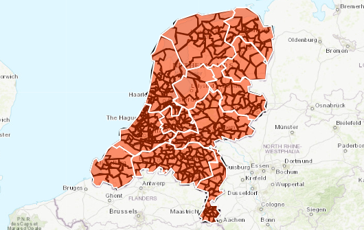
April 9, 2022 at 5:55 pm #6953KeymasterHere is a page with geojson for Dutch provinces and townships that you can download. I dragged them both into CODAP and got the map shown in the attached image and also the thumbnails for the case tables.
Attachments:
April 9, 2022 at 7:02 pm #6955Dan Damelin
KeymasterI wanted to learn a bit about the geojson format myself, so in playing around I made a version of the file you sent with the boundaries that have thumbnails.
To make this I ended up doing some combination of formulas in excel and cutting and pasting to make the geojson file from the data that was there. Then I imported the geojson into codap, exported that and pasted the new polygon features with added thumbnail over what was there in the csv.
(Bill I tried to join after importing the geojson but could not get that to work correctly.)
Attached is the geojson file I created as well.
April 9, 2022 at 7:04 pm #6957KeymasterI was blocked from uploading the geojson file so here’s a link to it:
April 10, 2022 at 3:40 pm #6959Thank you, Dan. At some point, I would love a tutorial on what you did to make a genuine geojson file from the one I sent you!
-
This topic was modified 2 years ago by
-
AuthorPosts
- You must be logged in to reply to this topic.