CODAP › Forums › CODAP Help Forum › linking map to data
Tagged: linking data to a map
- This topic has 10 replies, 3 voices, and was last updated 3 years, 2 months ago by
Bill Finzer.
-
AuthorPosts
-
traci_higgins@terc.edu
ParticipantWe’re thinking about using the UN dataset found in the “For Educators” part of the website under “Sample CODAP Datasets”. That dataset has countries as cases and we were wondering how to link them to a map – I haven’t done that before but I’ve been told it is pretty easy to do in CODAP. I thought I’d ask about how to do it here in case others have wondered how to link data to a map also.
-
This topic was modified 3 years, 5 months ago by
admin.
October 28, 2020 at 5:47 pm #5987Bill Finzer
KeymasterHi Traci,
Thanks for the post as I’m sure others have wondered about this. And it is easy.
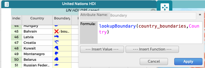
- Add a Boundary attribute to the dataset.
- Edit the formula of your new attribute as shown in the screen capture.
Here it is for copy/paste:
lookupBoundary(country_boundaries,Country) - When you Apply the formula you will see miniature maps appear as values for the attribute for most of the countries.
- Make a map! The countries should appear. Drag an attribute into the middle of the map to color the countries by the values of that attribute.
Caveats:
- Make the map after you add the Boundary attribute. An existing CODAP map might not pick up the change.
- The name of the attribute can be one of ‘boundary’, ‘boundaries’, ‘polygon’, ‘polygons’, ‘grenze’, ‘境界’
- If you want to name it something else, then you must set the attribute type to ‘boundary’ using the Edit Attribute Properties dialog box.
- Some countries may not appear on the map. This is because the name in your dataset doesn’t correspond exactly to the name in CODAP’s database. But you can fix that by looking up CODAP’s name in this document. (It helps to make a map so it’s easy to find the country you want.)
-
This reply was modified 3 years, 5 months ago by
January 19, 2021 at 10:36 pm #6201ParticipantHi Bill,
I created the boundary attribute following the very easy directions above (thanks!). And I used the embedded link to get to the index and fix any names that were not matching the index. However, some countries in the index have no data under the boundary index. How do we get what we need so that we can get those mapped too? Some examples are Hong Kong, Liechtenstein, Monaco, Barbados, Saint Lucia, etc. If the name is listed in the index but there is no value in the boundary column what should we do?
Thanks!
Traci
January 19, 2021 at 10:49 pm #6202ParticipantAlso I was wondering why some countries in the index of countries do not have boundary values. In this case, I’m asking for my own understanding.
Thanks!
Traci
January 20, 2021 at 5:15 pm #6203KeymasterHi Traci,
Thanks for this question! You have motivated me to find a more complete set of country boundary files and update our database with them. These will appear in the next release—0566. I think I added almost 100 new boundaries!
Here is a link to a shared view of the new boundaries so you can check out whether the countries you’re interested in will be present in the next build.
To attempt to answer your question, my memory is that at the time I simply wasn’t able to find boundaries for those entries that did not get boundary values. Apparently things are better now!
And a question for you: What are you working on that requires a more complete set of boundaries?
January 20, 2021 at 8:16 pm #6204ParticipantThanks Bill,
We are using a UN Dataset to look at equity in education and health with middle schoolers. We put in the boundaries so the kids can map the UN countries, but there are about 20 or so that have no boundary values in the current index. Those tend to be countries with some level of disputed autonomy or that are really small. Most of the countries do map, but it would be great to have all of them map, and we wanted to know why some don’t have boundaries in case the kids ask. Thanks for your helpful reply. We are looking forward to the next release!
January 20, 2021 at 8:21 pm #6205ParticipantOne other quick question, I was wondering when you are expecting the next release will be out.
Thanks!
Traci
January 20, 2021 at 8:32 pm #6206KeymasterEarliest would be 1/27. Latest would be a week after that.
January 20, 2021 at 8:37 pm #6207ParticipantYay!
February 3, 2021 at 5:56 pm #6292Just wondering, since it’s a week after 1/27, if there’s a new version coming out today. There were definitely some questions from kids when we introduced the UN dataset last week about the “holes” in the graph (i.e. areas that weren’t colored when we colored the graph by some variable) and I’m curious if I’ll be able to show them that the graph has been updated tomorrow.
Thanks!
February 3, 2021 at 6:02 pm #6293KeymasterHi Andee,
Build 0567 is in QA at the moment. If it passes, the release will be later today. I’ve got my fingers crossed!
Bill
-
This topic was modified 3 years, 5 months ago by
-
AuthorPosts

- You must be logged in to reply to this topic.