US County Boundries

Viewing 5 posts - 1 through 5 (of 5 total)
  • Author
    Posts
  • #6628 Score: 0

    Hi,

    I would like to play with data for counties and I want to create map boundaries as well. What ID attribute does CODAP need to use to look up function for US County Boundaries?


    Thanks,


    Travis

    #6629
    Bill Finzer
    Keymaster

    Hi Travis,

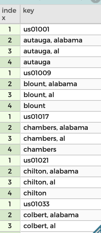
    CODAP allows for any of four keys to be used as you can see in the accompanying screenshot.

    Note that the simple county name is allowed, but, for common county names, will be insufficient. It was included for those situations in which a small number of counties are displayed, all with unambiguous names.

    Bill

    Attachments:
    #6631

    Thank Bill you are awesome!

    #13285
    Tim Erickson
    Participant

    And yet! I have a county attribute that includes the word “county” (or “parish”…) in the values, and that doesn’t work.

    Removing the word “county” or “parish” fixes the problem. It would be great if CODAP did that for me!

    #13286
    Tim Erickson
    Participant

    And yet! I have a county attribute that includes the word “county” (or “parish”…) in the values, and that doesn’t work.

    Removing the word “county” or “parish” fixes the problem. It would be great if CODAP did that for me!

Viewing 5 posts - 1 through 5 (of 5 total)
  • You must be logged in to reply to this topic.